Mt.Katahdin - Baxter State Park

Getting There
Baxter State Park, situated in the northern plains of Maine, U.S.A.,
is home to one of the most interesting winter mountain environments I've
ever visited. It reminded me in many ways of the Scottish highlands apart
from the temperatures and quality of the ice which were both much colder
and harder than I'd experienced before.
The trip started long before we arrived at the park. For myself it involved
driving round to Greg's, my usual climbing buddies house and then driving
the 9 hours up to Maine. The next day we met Pete and Phil at the Macdonald's
in Millinocket. Pete was the instigator of the trip and had been to the
park several times in the past.
We headed out of town towards the park down what is known as the "Golden
Road". This is a private road which is used to carry timber from
the local forests to the paper mill in Millinocket. There is no speed
limit. There doesn't seem to be a weight restriction and the timber trucks
certainly let you know that they own the road as they thunder towards
you swaying dangerously down the middle of the road. One of the rangers
later told us about some of the near misses and tragic accidents which
had occurred on the road. Apparently logs fall off the trucks regularly
or stick out several feet to catch the unwary driver.
At the entrance to the park, Pete unloaded the snow mobile which we would
use to ferry ourselves and our gear in while we packed all our stuff onto
sleds for the trip. The snow mobile trip was a little unnerving. We carried
3 people at a time dragging about 200 lbs. of gear behind. The sled got
out of control a couple of times and threatened to turn the snow mobile
over.
I was actually glad to leave the motorized transport behind and set off
skiing. It was 8 miles from where the snow mobile dropped us to the cabin
at "Roaring Brook". It was dark by the time we got there and
it didn't come soon enough. The sleds also ran out of control even at
the slow speeds we were skiing at. They'd occasionally wander off the
track and wrap themselves around a convenient tree, spoiling any rhythm
you might have had.
The cabins were pretty cramped although the log fire kept the place at
a stifling 80 degrees. Good enough for shorts.
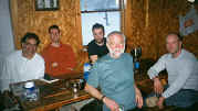 |
Left to right - Pete, Mat, Brad, Al (front), Phil.
|
The next morning we set off to complete the remaining 3.5 miles up a
much narrower and much steeper trail to finally arrive at the "Chimney
Pond" camp ground. The trail leads up through beautiful snow covered
pine forests which are a sufficient distraction that you don't notice
the sled which at times feels like you're dragging a dead horse behind.
The trail also crosses over a frozen lake which was the first time I noticed
just how strongly the wind was blowing and how quickly it sucked the heat
away from any exposed skin. It was certainly time to put on a few more
layers.
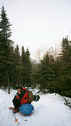
Pete takes a break on the trail.
|
|
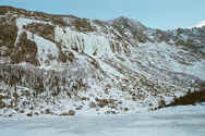
The impressive Pamola ice cliffs (300' grade 4's and 5's).
|
As we approached the cabin it was possible to see the impressive Katahdin
mountain rearing up in the background. Actually it's shaped like a huge
horse shoe which completely surrounds the cabin and the pond. The low
cloud meant that we couldn't see the summit but could only imagine how
fearsome it looked with the snow blowing off the peaks.
It started snowing before we got to the cabin and didn't stop until lunch
time the next day. During that evening the clouds kept lifting just enough
to catch glimpses of the impressive Pamola ice cliffs between the swirling
spin drift. The images were enough to conjure up some interesting dreams
of ice climbing.
Home
Climbing >>>
|


